Mesa de los Tres Reyes See also External links Navigation menu42°56′42″N 0°43′20″W / 42.94500°N 0.72222°W / 42.94500; -0.7222242°56′42″N 0°43′20″W / 42.94500°N 0.72222°W / 42.94500; -0.72222"Mesa de los Tres Reyes" on SummitpostMesa de los Tres Reyesexpanding iteexpanding ite
Mountains of the PyreneesMountains of AragonMountains of NavarreSpain geography stubsFrance geography stubs
BasqueAragoneseGasconFrenchPyreneesNavarreNavarre,AragonBéarn
| Mesa de los Tres Reyes | |
|---|---|
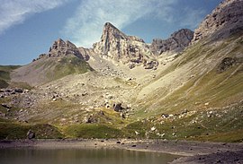 Mesa de los Tres Reyes viewed from Lac de Lhurs. | |
| Highest point | |
| Elevation | 2,428 m (7,966 ft) |
| Prominence | 392 m (1,286 ft) |
| Coordinates | 42°56′42″N 0°43′20″W / 42.94500°N 0.72222°W / 42.94500; -0.72222Coordinates: 42°56′42″N 0°43′20″W / 42.94500°N 0.72222°W / 42.94500; -0.72222 |
| Naming | |
| English translation | Table of the Three Kings |
| Language of name | Spanish |
| Geography | |
 Mesa de los Tres Reyes Location in Spain, on the border with France | |
| Location | Aragon/Navarre, Spain; France |
| Parent range | Pyrenees |
Mesa de los Tres Reyes (Basque: Hiru Erregeen Mahaia, Roncalese Basque: Iror Errege Maia, Aragonese: Meseta d'os Tres Reis, Gascon: Tabla d'eths Tros Rouyes, French: Table des Trois Rois) is a mountain of the Pyrenees. It is the highest point of Spanish Navarre, with an elevation of 2,428 metres (7,966 ft).
Its name, "The Table of the Three Kings", derives from the fact that the mountain is located at the confluence of the ancient kingdoms of Navarre, Aragon, and Béarn; where the three kings of those kingdoms met from time to time to discuss matters of importance.
See also
- Pyrenees
- Tossal dels Tres Reis
External links
- "Mesa de los Tres Reyes" on Summitpost
(in French) Mesa de los Tres Reyes, CamptoCamp.
This Spain location article is a stub. You can help Wikipedia by expanding it. |
This article related to geography of France is a stub. You can help Wikipedia by expanding it. |

