Grade II* listed buildings in Oxford Contents List of buildings See also Notes External links Navigation menuOpenStreetMapKMLGPXSP537550277051°43′16″N 1°13′24″W / 51.721086°N 1.223221°W / 51.721086; -1.223221 (Church of St Mary and St Nicholas)1047667SP545350228551°43′00″N 1°12′43″W / 51.71665°N 1.212006°W / 51.71665; -1.212006 (Minchery Farmhouse)1047672SP517110628551°45′10″N 1°15′08″W / 51.752878°N 1.252287°W / 51.752878; -1.252287 (All Souls College, Warden's Lodging)1046756SP534680550251°44′44″N 1°13′37″W / 51.745675°N 1.226956°W / 51.745675; -1.226956 (Bartlemas House)1047331SP516980611951°45′05″N 1°15′09″W / 51.751387°N 1.2525°W / 51.751387; -1.2525 (Beam Hall, with Number 3 Merton Street)1369414SP514460610951°45′05″N 1°15′22″W / 51.751321°N 1.256151°W / 51.751321; -1.256151 (Blue Boar Quadrangle at Christ Church)1408741SP515110625951°45′10″N 1°15′19″W / 51.752663°N 1.255188°W / 51.752663; -1.255188 (Brasenose College Staircase 16, 17 and 18)1369494SP510020608751°45′04″N 1°15′45″W / 51.751163°N 1.262586°W / 51.751163; -1.262586 (C Wing including the Round Tower)1047045SP513120593651°44′59″N 1°15′29″W / 51.749777°N 1.258118°W / 51.749777; -1.258118 (Campion Hall (including Chapel and Micklen Hall))1046738SP515650603751°45′02″N 1°15′16″W / 51.750662°N 1.254438°W / 51.750662; -1.254438 (Christ Church Picture Gallery)1323703SP515720613051°45′05″N 1°15′16″W / 51.751498°N 1.254323°W / 51.751498; -1.254323 (Christ Church: wall and screen facing Oriel Square in the north east corner of the college)1046744SP513550599951°45′01″N 1°15′27″W / 51.75034°N 1.257486°W / 51.75034; -1.257486 (Church of St Aldate)1100244SP544650763551°45′53″N 1°12′44″W / 51.764755°N 1.212184°W / 51.764755; -1.212184 (St Andrew's Church, Headington)1348376SP527060633051°45′11″N 1°14′16″W / 51.753191°N 1.237867°W / 51.753191; -1.237867 (Church of St Clement)1369413SP512030602451°45′02″N 1°15′35″W / 51.750579°N 1.259684°W / 51.750579; -1.259684 (Church of St Ebbe)1047355SP501540619151°45′08″N 1°16′29″W / 51.752175°N 1.274854°W / 51.752175; -1.274854 (Church of St Frideswide)1369349SP539840382551°43′50″N 1°13′11″W / 51.730548°N 1.219743°W / 51.730548; -1.219743 (Church of St James)1185096SP510530615851°45′06″N 1°15′43″W / 51.751797°N 1.261837°W / 51.751797; -1.261837 (County Hall with the curving screen walls and turrets on either side)1047201SP514440640051°45′14″N 1°15′22″W / 51.753937°N 1.256137°W / 51.753937; -1.256137 (Exeter College, Chapel on north side of quadrangle, Main Quadrangle)1046721SP511700625351°45′10″N 1°15′36″W / 51.75264°N 1.260128°W / 51.75264; -1.260128 (Frewin Hall)1122646SP512640684051°45′28″N 1°15′31″W / 51.757909°N 1.25868°W / 51.757909; -1.25868 (Garden House approximately 50 metres ENE of Number 16 (St Giles House))1047042SP512030680951°45′27″N 1°15′34″W / 51.757636°N 1.259568°W / 51.757636; -1.259568 (Gates and piers at Number 16, St Giles')1359647SP515030545051°44′43″N 1°15′20″W / 51.745391°N 1.255423°W / 51.745391; -1.255423 (Grandpont House)1299941SP510180603751°45′03″N 1°15′44″W / 51.750712°N 1.262361°W / 51.750712; -1.262361 (Greyfriars, 21 Paradise Street)1369431SP531680654751°45′18″N 1°13′52″W / 51.755098°N 1.231142°W / 51.755098; -1.231142 (Headington Hill Hall and attached forecourt wall)1047044SP516470643351°45′15″N 1°15′11″W / 51.754215°N 1.253192°W / 51.754215; -1.253192 (Hertford College, East Range)1369641SP516120642451°45′15″N 1°15′13″W / 51.754137°N 1.2537°W / 51.754137; -1.2537 (Hertford College, West Range)1046724SP516440655451°45′19″N 1°15′12″W / 51.755303°N 1.253217°W / 51.755303; -1.253217 (Holywell Music Room)1047232SP513100688451°45′30″N 1°15′29″W / 51.7583°N 1.258007°W / 51.7583; -1.258007 (Keble College, De Breyne and Hayward Buildings, including Middle Common Room and bar, Fellows flat, transformer station, workshops and gates)1130378SP514250616851°45′07″N 1°15′23″W / 51.751853°N 1.256447°W / 51.751853; -1.256447 (Kemp Hall)1145872SP521310610251°45′04″N 1°14′46″W / 51.751194°N 1.24623°W / 51.751194; -1.24623 (Magdalen Bridge)1369360SP519960654151°45′19″N 1°14′53″W / 51.755154°N 1.24812°W / 51.755154; -1.24812 (Magdalen College, boundary wall of the Grove)1046708SP519780624151°45′09″N 1°14′54″W / 51.752458°N 1.248426°W / 51.752458; -1.248426 (Magdalen College, the New School Room, now New Library)1283219SP520580623951°45′09″N 1°14′50″W / 51.752433°N 1.247267°W / 51.752433; -1.247267 (Magdalen College, the Old Grammar Hall)1046706SP519910618851°45′07″N 1°14′54″W / 51.751981°N 1.248245°W / 51.751981; -1.248245 (Magdalen Gate House)1047287SP516460681751°45′28″N 1°15′11″W / 51.757667°N 1.253149°W / 51.757667; -1.253149 (Mansfield College)1046678SP517390607851°45′04″N 1°15′07″W / 51.751015°N 1.251912°W / 51.751015; -1.251912 (Merton College, South Range Hall, Front Quadrangle)1369660SP518330640751°45′14″N 1°15′02″W / 51.753964°N 1.250501°W / 51.753964; -1.250501 (New College, iron screen, Garden Quadrangle)1046689SP513840596551°45′00″N 1°15′25″W / 51.750032°N 1.257071°W / 51.750032; -1.257071 (Pembroke College, Master's Lodging)1046665SP512900602751°45′02″N 1°15′30″W / 51.750598°N 1.258423°W / 51.750598; -1.258423 (Pembroke College, Staircase 16 (part of))1046667SP523430608251°45′03″N 1°14′35″W / 51.750799°N 1.243075°W / 51.750799; -1.243075 (Florey Building, Queen's College)1393211SP526880347851°43′39″N 1°14′19″W / 51.727552°N 1.238559°W / 51.727552; -1.238559 (Iffley Rectory)1047193SP515190680951°45′27″N 1°15′18″W / 51.757607°N 1.25499°W / 51.757607; -1.25499 (Rhodes House)1076964SP534280547051°44′43″N 1°13′39″W / 51.745391°N 1.227541°W / 51.745391; -1.227541 (St Bartholomew's Farmhouse)1299369SP510900622251°45′09″N 1°15′41″W / 51.752369°N 1.261291°W / 51.752369; -1.261291 (St Peter's College, Master's Lodge, former Oxford Canal Company offices)1046618SP525950351951°43′41″N 1°14′24″W / 51.727929°N 1.239899°W / 51.727929; -1.239899 (Stable wing and garden walls of Iffley Rectory)1369399SP525130599951°45′01″N 1°14′27″W / 51.750233°N 1.240713°W / 51.750233; -1.240713 (Stones Almshouses (8 tenements))1047125SP512120682151°45′28″N 1°15′34″W / 51.757743°N 1.259436°W / 51.757743; -1.259436 (The Judges Lodging)1047136SP504470943551°46′53″N 1°16′13″W / 51.781313°N 1.27014°W / 51.781313; -1.27014 (Summertown Villa, formerly The Lodge, 304, Woodstock Road)1246138SP512450652551°45′18″N 1°15′32″W / 51.755079°N 1.259002°W / 51.755079; -1.259002 (The Martyrs' Memorial)1107172SP514500622251°45′08″N 1°15′22″W / 51.752336°N 1.256077°W / 51.752336; -1.256077 (The Mitre Hotel)1369357SP510740649951°45′17″N 1°15′41″W / 51.754861°N 1.261482°W / 51.754861; -1.261482 (The Playhouse, Beaumont Street)1185150SP510090707351°45′36″N 1°15′44″W / 51.760027°N 1.26234°W / 51.760027; -1.26234 (The Radcliffe Infirmary (Main Block))1047066SP516140623351°45′09″N 1°15′13″W / 51.75242°N 1.253699°W / 51.75242; -1.253699 (Rhodes Building, north range of St Mary's Quad, Oriel College)1046662SP508580691451°45′31″N 1°15′52″W / 51.758611°N 1.264551°W / 51.758611; -1.264551 (The University Printing House (the Clarendon Press))1052359SP513790613651°45′06″N 1°15′26″W / 51.751569°N 1.257118°W / 51.751569; -1.257118 (Oxford Town Hall, Municipal Buildings and Library)1047153SP514990662651°45′21″N 1°15′19″W / 51.755964°N 1.255307°W / 51.755964; -1.255307 (Trinity College, gatepiers and grille)1046630SP514600647651°45′17″N 1°15′21″W / 51.754619°N 1.255894°W / 51.754619; -1.255894 (Trinity College, Kettell Hall)1230901SP516400623951°45′09″N 1°15′12″W / 51.752471°N 1.253322°W / 51.752471; -1.253322 (Tudor House, 94 High Street/1 Magpie Lane)1369388SP520090675851°45′26″N 1°14′52″W / 51.757103°N 1.2479°W / 51.757103; -1.2479 (University of Oxford, St Cross Building)1369496SP511940634051°45′12″N 1°15′35″W / 51.75342°N 1.259768°W / 51.75342; -1.259768 (Vanbrugh House, St Michael's Street)1068871SP515460656651°45′20″N 1°15′17″W / 51.75542°N 1.254635°W / 51.75542; -1.254635 (Wadham College, South Block)1046599SP512920634951°45′13″N 1°15′30″W / 51.753492°N 1.258347°W / 51.753492; -1.258347 (26 Ship Street)1047091SP510640652551°45′18″N 1°15′42″W / 51.755095°N 1.261623°W / 51.755095; -1.261623 (24–37 Beaumont Street)1047375SP518120624451°45′09″N 1°15′03″W / 51.752501°N 1.25083°W / 51.752501; -1.25083 (86 and 87 High Street)1047248SP516300653451°45′18″N 1°15′12″W / 51.755125°N 1.253423°W / 51.755125; -1.253423 (35 Holywell Street)1047234SP511380680851°45′27″N 1°15′38″W / 51.757633°N 1.26051°W / 51.757633; -1.26051 (41 St Giles Street)1047144SP515910616551°45′07″N 1°15′15″W / 51.751811°N 1.254043°W / 51.751811; -1.254043 (12 Oriel Street)1047173SP514040583451°44′56″N 1°15′24″W / 51.748852°N 1.2568°W / 51.748852; -1.2568 (82 and 83 St Aldates Street)1047154SP515680621851°45′08″N 1°15′16″W / 51.752289°N 1.254368°W / 51.752289; -1.254368 (106 and 107 High Street)1047253SP513710620651°45′08″N 1°15′26″W / 51.752199°N 1.257223°W / 51.752199; -1.257223 (6 High Street)1047311SP511270681651°45′28″N 1°15′38″W / 51.757706°N 1.260668°W / 51.757706; -1.260668 (40 St Giles Street)1068575SP513180602351°45′02″N 1°15′29″W / 51.750559°N 1.258018°W / 51.750559; -1.258018 (13 and 14 Pembroke Street)1099196SP512930604051°45′03″N 1°15′30″W / 51.750714°N 1.258378°W / 51.750714; -1.258378 (38 Pembroke Street)1369435SP511540674351°45′25″N 1°15′37″W / 51.757047°N 1.260288°W / 51.757047; -1.260288 (53 and 54 St Giles Street)1369439SP514920620251°45′08″N 1°15′20″W / 51.752152°N 1.255471°W / 51.752152; -1.255471 (118 High Street)1047257SP513400621551°45′08″N 1°15′28″W / 51.752283°N 1.257671°W / 51.752283; -1.257671 (3 Cornmarket Street)1185643e
BedfordshireBerkshireBristolBuckinghamshireCambridgeshireCheshireCornwallCumbriaDerbyshireDevonDorsetDurhamEast SussexEast Riding of YorkshireEssexGloucestershireGreater LondonGreater ManchesterHampshireHerefordshireHertfordshireIsle of WightKentLancashireLeicestershireLincolnshireMerseysideNorfolkNorth YorkshireNorthamptonshireNorthumberlandNottinghamshireOxfordshireRutlandShropshireSomersetSouth YorkshireStaffordshireSuffolkSurreyTyne and WearWarwickshireWest MidlandsWest SussexWest YorkshireWiltshireWorcestershireSignal boxesWar memorials
Buildings and structures in OxfordGrade II* listed buildings in OxfordGrade II* listed buildings in OxfordshireLists of listed buildings in EnglandLists of buildings and structures in Oxfordshire
Grade II* listed buildingsOxford![]() Grade II* listed buildings in Oxfordshire
Grade II* listed buildings in Oxfordshire
There are over 20,000 Grade II* listed buildings in England. This page is a list of these buildings in the district of Oxford in Oxfordshire.
Contents
1 List of buildings
2 See also
3 Notes
4 External links
List of buildings
| Name | Location | Type | Completed [note 1] | Date designated | Grid ref.[note 2] Geo-coordinates | Entry number [note 3] | Image |
|---|---|---|---|---|---|---|---|
Church of St Mary and St Nicholas | Littlemore | Church | 1836 | 18 July 1963 | SP5375502770 51°43′16″N 1°13′24″W / 51.721086°N 1.223221°W / 51.721086; -1.223221 (Church of St Mary and St Nicholas) | 1047667 | 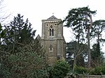 More images |
| Minchery Farmhouse | Littlemore | Farmhouse | c. 1600 | 18 July 1963 | SP5453502285 51°43′00″N 1°12′43″W / 51.71665°N 1.212006°W / 51.71665; -1.212006 (Minchery Farmhouse) | 1047672 |  More images |
All Souls College, Warden's Lodging | All Souls College | House | 1704 | 12 January 1954 | SP5171106285 51°45′10″N 1°15′08″W / 51.752878°N 1.252287°W / 51.752878; -1.252287 (All Souls College, Warden's Lodging) | 1046756 | 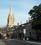 More images |
| Bartlemas House | Oxford | House | 1649 | 12 January 1954 | SP5346805502 51°44′44″N 1°13′37″W / 51.745675°N 1.226956°W / 51.745675; -1.226956 (Bartlemas House) | 1047331 |  More images |
| Beam Hall, with Number 3 Merton Street | Oxford | House | 15th century and c. 1600 | 12 January 1954 | SP5169806119 51°45′05″N 1°15′09″W / 51.751387°N 1.2525°W / 51.751387; -1.2525 (Beam Hall, with Number 3 Merton Street) | 1369414 |  |
Blue Boar Quadrangle at Christ Church | Oxford | College lodgings | 1968 | 10 October 2006 | SP5144606109 51°45′05″N 1°15′22″W / 51.751321°N 1.256151°W / 51.751321; -1.256151 (Blue Boar Quadrangle at Christ Church) | 1408741 |  |
| Brasenose College Staircase 16, 17 and 18 | Brasenose College | College lodgings | 1961 | 30 March 1998 | SP5151106259 51°45′10″N 1°15′19″W / 51.752663°N 1.255188°W / 51.752663; -1.255188 (Brasenose College Staircase 16, 17 and 18) | 1369494 |  |
| C Wing including the Round Tower | Oxford Castle | Prison | From 1785, perhaps partly on 13th century foundations | 28 June 1972 | SP5100206087 51°45′04″N 1°15′45″W / 51.751163°N 1.262586°W / 51.751163; -1.262586 (C Wing including the Round Tower) | 1047045 |  |
Campion Hall (including Chapel and Micklen Hall) | Campion Hall | College building incorporating house | 1936 and late 17th/early 18th century | 12 January 1954 | SP5131205936 51°44′59″N 1°15′29″W / 51.749777°N 1.258118°W / 51.749777; -1.258118 (Campion Hall (including Chapel and Micklen Hall)) | 1046738 |  More images |
Christ Church Picture Gallery | Oxford | Art gallery | 1965–68 | 24 April 1998 | SP5156506037 51°45′02″N 1°15′16″W / 51.750662°N 1.254438°W / 51.750662; -1.254438 (Christ Church Picture Gallery) | 1323703 |  |
| Christ Church: wall and screen facing Oriel Square in the north east corner of the college | Christ Church | Gate | 18th century | 28 June 1972 | SP5157206130 51°45′05″N 1°15′16″W / 51.751498°N 1.254323°W / 51.751498; -1.254323 (Christ Church: wall and screen facing Oriel Square in the north east corner of the college) | 1046744 |  |
Church of St Aldate | Oxford | Church | 12th century | 12 January 1954 | SP5135505999 51°45′01″N 1°15′27″W / 51.75034°N 1.257486°W / 51.75034; -1.257486 (Church of St Aldate) | 1100244 |  More images |
St Andrew's Church, Headington | Oxford | Church | Mid-12th century | 12 January 1954 | SP5446507635 51°45′53″N 1°12′44″W / 51.764755°N 1.212184°W / 51.764755; -1.212184 (St Andrew's Church, Headington) | 1348376 |  More images |
Church of St Clement | Oxford | Church | 1827–28 | 12 January 1954 | SP5270606330 51°45′11″N 1°14′16″W / 51.753191°N 1.237867°W / 51.753191; -1.237867 (Church of St Clement) | 1369413 |  More images |
Church of St Ebbe | Oxford | Church | 13th century | 12 January 1954 | SP5120306024 51°45′02″N 1°15′35″W / 51.750579°N 1.259684°W / 51.750579; -1.259684 (Church of St Ebbe) | 1047355 |  More images |
Church of St Frideswide | Oxford | Church | 1872 | 29 January 1968 | SP5015406191 51°45′08″N 1°16′29″W / 51.752175°N 1.274854°W / 51.752175; -1.274854 (Church of St Frideswide) | 1369349 |  More images |
| Church of St James | Oxford | Church | Late 12th century | 12 January 1954 | SP5398403825 51°43′50″N 1°13′11″W / 51.730548°N 1.219743°W / 51.730548; -1.219743 (Church of St James) | 1185096 | 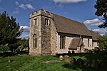 More images |
| County Hall with the curving screen walls and turrets on either side | Oxford | Local government office with lamp brackets | 1841 | 29 January 1968 | SP5105306158 51°45′06″N 1°15′43″W / 51.751797°N 1.261837°W / 51.751797; -1.261837 (County Hall with the curving screen walls and turrets on either side) | 1047201 |  More images |
Exeter College, Chapel on north side of quadrangle, Main Quadrangle | Exeter College | College chapel | 1859 | 12 January 1954 | SP5144406400 51°45′14″N 1°15′22″W / 51.753937°N 1.256137°W / 51.753937; -1.256137 (Exeter College, Chapel on north side of quadrangle, Main Quadrangle) | 1046721 | 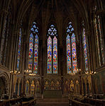 More images |
| Frewin Hall | Oxford | House | 1582 | 12 January 1954 | SP5117006253 51°45′10″N 1°15′36″W / 51.75264°N 1.260128°W / 51.75264; -1.260128 (Frewin Hall) | 1122646 |  |
| Garden House approximately 50 metres ENE of Number 16 (St Giles House) | Oxford | Garden house | c. 1737 | 27 July 1989 | SP5126406840 51°45′28″N 1°15′31″W / 51.757909°N 1.25868°W / 51.757909; -1.25868 (Garden House approximately 50 metres ENE of Number 16 (St Giles House)) | 1047042 | |
| Gates and piers at Number 16, St Giles' | Oxford | Gate | c. 1702 | 28 June 1972 | SP5120306809 51°45′27″N 1°15′34″W / 51.757636°N 1.259568°W / 51.757636; -1.259568 (Gates and piers at Number 16, St Giles') | 1359647 |  |
Grandpont House | Oxford | House | c. 1785 | 12 January 1954 | SP5150305450 51°44′43″N 1°15′20″W / 51.745391°N 1.255423°W / 51.745391; -1.255423 (Grandpont House) | 1299941 |  |
| Greyfriars, 21 Paradise Street | Oxford | House | Late 17th century | 12 January 1954 | SP5101806037 51°45′03″N 1°15′44″W / 51.750712°N 1.262361°W / 51.750712; -1.262361 (Greyfriars, 21 Paradise Street) | 1369431 |  |
Headington Hill Hall and attached forecourt wall | Oxford | Country house | 1856–58 | 7 December 1992 | SP5316806547 51°45′18″N 1°13′52″W / 51.755098°N 1.231142°W / 51.755098; -1.231142 (Headington Hill Hall and attached forecourt wall) | 1047044 | 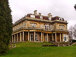 |
Hertford College, East Range | Hertford College | University college | 1740 | 12 January 1954 | SP5164706433 51°45′15″N 1°15′11″W / 51.754215°N 1.253192°W / 51.754215; -1.253192 (Hertford College, East Range) | 1369641 |  More images |
Hertford College, West Range | Hertford College | College lodgings | 1820–22 | 12 January 1954 | SP5161206424 51°45′15″N 1°15′13″W / 51.754137°N 1.2537°W / 51.754137; -1.2537 (Hertford College, West Range) | 1046724 |  More images |
Holywell Music Room | Oxford | Music room | 1742–48 | 12 January 1954 | SP5164406554 51°45′19″N 1°15′12″W / 51.755303°N 1.253217°W / 51.755303; -1.253217 (Holywell Music Room) | 1047232 |  |
Keble College, De Breyne and Hayward Buildings, including Middle Common Room and bar, Fellows flat, transformer station, workshops and gates | Oxford | Apartment | 1971–73 | 4 October 1999 | SP5131006884 51°45′30″N 1°15′29″W / 51.7583°N 1.258007°W / 51.7583; -1.258007 (Keble College, De Breyne and Hayward Buildings, including Middle Common Room and bar, Fellows flat, transformer station, workshops and gates) | 1130378 |  |
| Kemp Hall | Oxford | Cross-passage house | 1637 | 12 January 1954 | SP5142506168 51°45′07″N 1°15′23″W / 51.751853°N 1.256447°W / 51.751853; -1.256447 (Kemp Hall) | 1145872 |  |
Magdalen Bridge | Oxford | Bridge | 1772–90 | 12 January 1954 | SP5213106102 51°45′04″N 1°14′46″W / 51.751194°N 1.24623°W / 51.751194; -1.24623 (Magdalen Bridge) | 1369360 |  More images |
Magdalen College, boundary wall of the Grove | Magdalen College | Boundary wall | Late 15th century | 12 January 1954 | SP5199606541 51°45′19″N 1°14′53″W / 51.755154°N 1.24812°W / 51.755154; -1.24812 (Magdalen College, boundary wall of the Grove) | 1046708 |  More images |
Magdalen College, the New School Room, now New Library | Magdalen College | Library | 1851 | 12 January 1954 | SP5197806241 51°45′09″N 1°14′54″W / 51.752458°N 1.248426°W / 51.752458; -1.248426 (Magdalen College, the New School Room, now New Library) | 1283219 |  More images |
Magdalen College, the Old Grammar Hall | Magdalen College | University college | 1614 | 12 January 1954 | SP5205806239 51°45′09″N 1°14′50″W / 51.752433°N 1.247267°W / 51.752433; -1.247267 (Magdalen College, the Old Grammar Hall) | 1046706 |  |
| Magdalen Gate House | Oxford | Gatehouse | Late 18th century | 12 January 1954 | SP5199106188 51°45′07″N 1°14′54″W / 51.751981°N 1.248245°W / 51.751981; -1.248245 (Magdalen Gate House) | 1047287 | 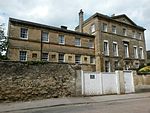 |
Mansfield College | Mansfield College | Theological college | 1886 | 12 January 1954 | SP5164606817 51°45′28″N 1°15′11″W / 51.757667°N 1.253149°W / 51.757667; -1.253149 (Mansfield College) | 1046678 |  More images |
Merton College, South Range Hall, Front Quadrangle | Merton College | Assembly hall | 13th century | 12 January 1954 | SP5173906078 51°45′04″N 1°15′07″W / 51.751015°N 1.251912°W / 51.751015; -1.251912 (Merton College, South Range Hall, Front Quadrangle) | 1369660 |  More images |
New College, iron screen, Garden Quadrangle | New College | University college | 1711 | 12 January 1954 | SP5183306407 51°45′14″N 1°15′02″W / 51.753964°N 1.250501°W / 51.753964; -1.250501 (New College, iron screen, Garden Quadrangle) | 1046689 |  More images |
Pembroke College, Master's Lodging | Pembroke College | Teachers' house, former Almshouses | Early 16th century, converted 1927 | 12 January 1954 | SP5138405965 51°45′00″N 1°15′25″W / 51.750032°N 1.257071°W / 51.750032; -1.257071 (Pembroke College, Master's Lodging) | 1046665 | 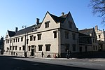 |
Pembroke College, Staircase 16 (part of) | Pembroke College | College lodgings | Early 17th century | 12 January 1954 | SP5129006027 51°45′02″N 1°15′30″W / 51.750598°N 1.258423°W / 51.750598; -1.258423 (Pembroke College, Staircase 16 (part of)) | 1046667 |  |
| Florey Building, Queen's College | St Clement's | College lodgings | 1971 | 12 March 2009 | SP5234306082 51°45′03″N 1°14′35″W / 51.750799°N 1.243075°W / 51.750799; -1.243075 (Florey Building, Queen's College) | 1393211 |  |
| Iffley Rectory | Oxford | Vicarage | 13th century | 12 January 1954 | SP5268803478 51°43′39″N 1°14′19″W / 51.727552°N 1.238559°W / 51.727552; -1.238559 (Iffley Rectory) | 1047193 |  More images |
Rhodes House | Oxford | University building with Library | 1929 | 12 January 1954 | SP5151906809 51°45′27″N 1°15′18″W / 51.757607°N 1.25499°W / 51.757607; -1.25499 (Rhodes House) | 1076964 |  More images |
| St Bartholomew's Farmhouse | Oxford | Farmhouse | 16th century | 12 January 1954 | SP5342805470 51°44′43″N 1°13′39″W / 51.745391°N 1.227541°W / 51.745391; -1.227541 (St Bartholomew's Farmhouse) | 1299369 | 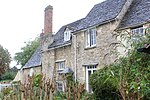 |
St Peter's College, Master's Lodge, former Oxford Canal Company offices | St Peter's College | University college, former office | 1829 | 12 January 1954 | SP5109006222 51°45′09″N 1°15′41″W / 51.752369°N 1.261291°W / 51.752369; -1.261291 (St Peter's College, Master's Lodge, former Oxford Canal Company offices) | 1046618 |  More images |
| Stable wing and garden walls of Iffley Rectory | Oxford | Gate | 18th century | 12 January 1954 | SP5259503519 51°43′41″N 1°14′24″W / 51.727929°N 1.239899°W / 51.727929; -1.239899 (Stable wing and garden walls of Iffley Rectory) | 1369399 | 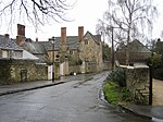 |
| Stones Almshouses (8 tenements) | Oxford | Almshouse | 1700 | 12 January 1954 | SP5251305999 51°45′01″N 1°14′27″W / 51.750233°N 1.240713°W / 51.750233; -1.240713 (Stones Almshouses (8 tenements)) | 1047125 |  |
| The Judges Lodging | Oxford | House | 1702 | 12 January 1954 | SP5121206821 51°45′28″N 1°15′34″W / 51.757743°N 1.259436°W / 51.757743; -1.259436 (The Judges Lodging) | 1047136 | 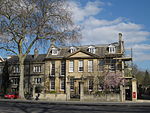 More images |
| Summertown Villa, formerly The Lodge, 304, Woodstock Road | Oxford | Villa | c. 1830 | 6 June 2001 | SP5044709435 51°46′53″N 1°16′13″W / 51.781313°N 1.27014°W / 51.781313; -1.27014 (Summertown Villa, formerly The Lodge, 304, Woodstock Road) | 1246138 | 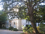 |
| The Martyrs' Memorial | Oxford | Commemorative monument | 1841 | 12 January 1954 | SP5124506525 51°45′18″N 1°15′32″W / 51.755079°N 1.259002°W / 51.755079; -1.259002 (The Martyrs' Memorial) | 1107172 |  More images |
| The Mitre Hotel | Oxford | Inn | c. 1300 | 12 January 1954 | SP5145006222 51°45′08″N 1°15′22″W / 51.752336°N 1.256077°W / 51.752336; -1.256077 (The Mitre Hotel) | 1369357 |  More images |
The Playhouse, Beaumont Street | Oxford | Theatre | 1938 | 12 January 1954 | SP5107406499 51°45′17″N 1°15′41″W / 51.754861°N 1.261482°W / 51.754861; -1.261482 (The Playhouse, Beaumont Street) | 1185150 |  |
| The Radcliffe Infirmary (Main Block) | Oxford | Infirmary | 1759–70 | 12 January 1954 | SP5100907073 51°45′36″N 1°15′44″W / 51.760027°N 1.26234°W / 51.760027; -1.26234 (The Radcliffe Infirmary (Main Block)) | 1047066 | 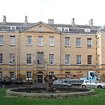 |
| Rhodes Building, north range of St Mary's Quad, Oriel College | Oxford | University college | 1909–11 | 28 June 1972 | SP5161406233 51°45′09″N 1°15′13″W / 51.75242°N 1.253699°W / 51.75242; -1.253699 (Rhodes Building, north range of St Mary's Quad, Oriel College) | 1046662 | 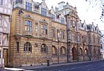 More images |
| The University Printing House (the Clarendon Press) | Oxford | Printing works | 1826–28 | 12 January 1954 | SP5085806914 51°45′31″N 1°15′52″W / 51.758611°N 1.264551°W / 51.758611; -1.264551 (The University Printing House (the Clarendon Press)) | 1052359 |  More images |
Oxford Town Hall, Municipal Buildings and Library | Oxford | Local government office | 1893–97 | 12 January 1954 | SP5137906136 51°45′06″N 1°15′26″W / 51.751569°N 1.257118°W / 51.751569; -1.257118 (Oxford Town Hall, Municipal Buildings and Library) | 1047153 |  More images |
Trinity College, gatepiers and grille | Trinity College | Gate pier | 1713 | 12 January 1954 | SP5149906626 51°45′21″N 1°15′19″W / 51.755964°N 1.255307°W / 51.755964; -1.255307 (Trinity College, gatepiers and grille) | 1046630 |  More images |
Trinity College, Kettell Hall | Trinity College | House | 1618–20 | 12 January 1954 | SP5146006476 51°45′17″N 1°15′21″W / 51.754619°N 1.255894°W / 51.754619; -1.255894 (Trinity College, Kettell Hall) | 1230901 |  |
| Tudor House, 94 High Street/1 Magpie Lane | Oxford | Timber-framed house | 16th century | 12 January 1954 | SP5164006239 51°45′09″N 1°15′12″W / 51.752471°N 1.253322°W / 51.752471; -1.253322 (Tudor House, 94 High Street/1 Magpie Lane) | 1369388 |  |
| University of Oxford, St Cross Building | Oxford | University building with libraries | 1961–65 | 30 March 1993 | SP5200906758 51°45′26″N 1°14′52″W / 51.757103°N 1.2479°W / 51.757103; -1.2479 (University of Oxford, St Cross Building) | 1369496 | |
| Vanbrugh House, St Michael's Street | Oxford | House | 17th century | 12 January 1954 | SP5119406340 51°45′12″N 1°15′35″W / 51.75342°N 1.259768°W / 51.75342; -1.259768 (Vanbrugh House, St Michael's Street) | 1068871 | 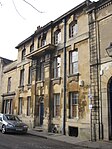 |
Wadham College, South Block | Wadham College | Gate | 1694, c. 1796 | 12 January 1954 | SP5154606566 51°45′20″N 1°15′17″W / 51.75542°N 1.254635°W / 51.75542; -1.254635 (Wadham College, South Block) | 1046599 |  |
| 26 Ship Street | Oxford | House | 15th century | 12 January 1954 | SP5129206349 51°45′13″N 1°15′30″W / 51.753492°N 1.258347°W / 51.753492; -1.258347 (26 Ship Street) | 1047091 |  |
| 24–37 Beaumont Street | Oxford | House | 1828–37 | 12 January 1954 | SP5106406525 51°45′18″N 1°15′42″W / 51.755095°N 1.261623°W / 51.755095; -1.261623 (24–37 Beaumont Street) | 1047375 | 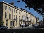 |
| 86 and 87 High Street | Oxford | House | Early 17th century | 12 January 1954 | SP5181206244 51°45′09″N 1°15′03″W / 51.752501°N 1.25083°W / 51.752501; -1.25083 (86 and 87 High Street) | 1047248 |  |
| 35 Holywell Street | Oxford | House | 1626 | 12 January 1954 | SP5163006534 51°45′18″N 1°15′12″W / 51.755125°N 1.253423°W / 51.755125; -1.253423 (35 Holywell Street) | 1047234 |  |
| 41 St Giles Street | Oxford | House | c. 1700 | 12 January 1954 | SP5113806808 51°45′27″N 1°15′38″W / 51.757633°N 1.26051°W / 51.757633; -1.26051 (41 St Giles Street) | 1047144 | 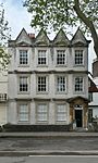 |
| 12 Oriel Street | Oxford | Timber-framed house | 17th century | 12 January 1954 | SP5159106165 51°45′07″N 1°15′15″W / 51.751811°N 1.254043°W / 51.751811; -1.254043 (12 Oriel Street) | 1047173 | 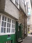 |
| 82 and 83 St Aldates Street | Oxford | House | 15th century | 12 January 1954 | SP5140405834 51°44′56″N 1°15′24″W / 51.748852°N 1.2568°W / 51.748852; -1.2568 (82 and 83 St Aldates Street) | 1047154 | 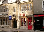 More images |
| 106 and 107 High Street | Oxford | House | 14th century | 12 January 1954 | SP5156806218 51°45′08″N 1°15′16″W / 51.752289°N 1.254368°W / 51.752289; -1.254368 (106 and 107 High Street) | 1047253 |  |
| 6 High Street | Oxford | House | Late 18th century | 12 January 1954 | SP5137106206 51°45′08″N 1°15′26″W / 51.752199°N 1.257223°W / 51.752199; -1.257223 (6 High Street) | 1047311 | 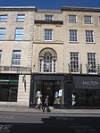 |
| 40 St Giles Street | Oxford | House | Late 17th century | 12 January 1954 | SP5112706816 51°45′28″N 1°15′38″W / 51.757706°N 1.260668°W / 51.757706; -1.260668 (40 St Giles Street) | 1068575 | 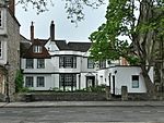 |
| 13 and 14 Pembroke Street | Oxford | House | 1641; altered in 18th–19th centuries | 12 January 1954 | SP5131806023 51°45′02″N 1°15′29″W / 51.750559°N 1.258018°W / 51.750559; -1.258018 (13 and 14 Pembroke Street) | 1099196 |  |
| 38 Pembroke Street | Oxford | Timber-framed house | 17th century | 12 January 1954 | SP5129306040 51°45′03″N 1°15′30″W / 51.750714°N 1.258378°W / 51.750714; -1.258378 (38 Pembroke Street) | 1369435 |  |
| 53 and 54 St Giles Street | Oxford | House | c. 1600 | 12 January 1954 | SP5115406743 51°45′25″N 1°15′37″W / 51.757047°N 1.260288°W / 51.757047; -1.260288 (53 and 54 St Giles Street) | 1369439 | 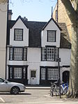 More images |
| 118 High Street | Oxford | House | 16th century, refronted in 19th century | 12 January 1954 | SP5149206202 51°45′08″N 1°15′20″W / 51.752152°N 1.255471°W / 51.752152; -1.255471 (118 High Street) | 1047257 | 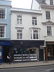 |
| 3 Cornmarket Street | Oxford | House | 15th to 17th century | 12 January 1954 | SP5134006215 51°45′08″N 1°15′28″W / 51.752283°N 1.257671°W / 51.752283; -1.257671 (3 Cornmarket Street) | 1185643 |  |
See also
- Grade I listed buildings in Oxford
- Grade II* listed buildings in Cherwell (district)
- Grade II* listed buildings in South Oxfordshire
- Grade II* listed buildings in Vale of White Horse
- Grade II* listed buildings in West Oxfordshire
Notes
^ The date given is the date used by Historic England as significant for the initial building or that of an important part in the structure's description.
^ Sometimes known as OSGB36, the grid reference is based on the British national grid reference system used by the Ordnance Survey.
^ The "List Entry Number" is a unique number assigned to each listed building and scheduled monument by Historic England.
External links
![]() Media related to Grade II* listed buildings in Oxfordshire at Wikimedia Commons
Media related to Grade II* listed buildings in Oxfordshire at Wikimedia Commons

