Unterstammheim Contents Geography Demographics Transport References External links Navigation menu47°38′N 8°47′E / 47.633°N 8.783°E / 47.633; 8.78347°38′N 8°47′E / 47.633°N 8.783°E / 47.633; 8.783www.unterstammheim.chSFSO statistics[update][update][update][update]"Arealstatistik Standard - Gemeinden nach 4 Hauptbereichen"Swiss Federal Statistical Office"STAT-TAB – Ständige und nichtständige Wohnbevölkerung nach institutionellen Gliederungen, Geburtsort und Staatsangehörigkeit"map.geo.admin.ch"S-Bahn trains, buses and boats"the originalOfficial website
Former municipalities of the canton of Zürich
municipalityAndelfingencantonZürichSwitzerlandOberstammheimWaltalingenStammheimSVPCSPFDPGreen Partyupper secondary educationprimary economic sectorsecondary sectortertiary sectorStammheim railway stationZurich S-BahnS29WinterthurStein am Rhein
Unterstammheim | |
|---|---|
Former municipality of Switzerland | |
 | |
 Coat of arms | |
Location of Unterstammheim | |
 Unterstammheim Show map of Switzerland  Unterstammheim Show map of Canton of Zurich | |
| Coordinates: 47°38′N 8°47′E / 47.633°N 8.783°E / 47.633; 8.783Coordinates: 47°38′N 8°47′E / 47.633°N 8.783°E / 47.633; 8.783 | |
| Country | Switzerland |
| Canton | Zurich |
| District | Andelfingen |
| Area [1] | |
| • Total | 7.32 km2 (2.83 sq mi) |
| Elevation | 433 m (1,421 ft) |
| Population (2017-12-31)[2] | |
| • Total | 891 |
| • Density | 120/km2 (320/sq mi) |
| Postal code | 8476 |
| SFOS number | 0042 |
| Surrounded by | Basadingen-Schlattingen (TG), Diessenhofen (TG), Oberstammheim, Wagenhausen (TG), Waltalingen |
| Website | www.unterstammheim.ch SFSO statistics |
Unterstammheim is a former municipality in the district of Andelfingen in the canton of Zürich in Switzerland. On 1 January 2019 the former municipalities of Oberstammheim, Unterstammheim and Waltalingen merged into the new municipality of Stammheim.
Contents
1 Geography
2 Demographics
3 Transport
4 References
5 External links
Geography

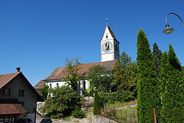
Unterstammheim church
Unterstammheim has an area of 7.3 km2 (2.8 sq mi). Of this area, 52.8% is used for agricultural purposes, while 36.2% is forested. Of the rest of the land, 10.6% is settled (buildings or roads) and the remainder (0.4%) is non-productive (rivers, glaciers or mountains).[3]
Demographics
Unterstammheim has a population (as of 31 December 2017) of 891.[4] As of 2007[update], 7.0% of the population was made up of foreign nationals. Over the last 10 years the population has decreased at a rate of -0.3%. Most of the population (as of 2000[update]) speaks German (96.1%), with Albanian being second most common ( 1.8%) and Portuguese being third ( 0.6%).
In the 2007 election the most popular party was the SVP which received 35.7% of the vote. The next three most popular parties were the CSP (16.5%), the FDP (13.5%) and the Green Party (13.3%).
The age distribution of the population (as of 2000[update]) is children and teenagers (0–19 years old) make up 30.4% of the population, while adults (20–64 years old) make up 55.7% and seniors (over 64 years old) make up 13.8%. In Unterstammheim about 84.3% of the population (between age 25-64) have completed either non-mandatory upper secondary education or additional higher education (either university or a Fachhochschule).
Unterstammheim has an unemployment rate of 1.54%. As of 2005[update], there were 116 people employed in the primary economic sector and about 30 businesses involved in this sector. 83 people are employed in the secondary sector and there are 11 businesses in this sector. 234 people are employed in the tertiary sector, with 37 businesses in this sector.[3]
Transport
Stammheim railway station, situated in Unterstammheim, is served by Zurich S-Bahn line S29, which links Winterthur and Stein am Rhein.[5][6]
References
^ ab "Arealstatistik Standard - Gemeinden nach 4 Hauptbereichen". Federal Statistical Office. Retrieved 13 January 2019..mw-parser-output cite.citationfont-style:inherit.mw-parser-output .citation qquotes:"""""""'""'".mw-parser-output .citation .cs1-lock-free abackground:url("//upload.wikimedia.org/wikipedia/commons/thumb/6/65/Lock-green.svg/9px-Lock-green.svg.png")no-repeat;background-position:right .1em center.mw-parser-output .citation .cs1-lock-limited a,.mw-parser-output .citation .cs1-lock-registration abackground:url("//upload.wikimedia.org/wikipedia/commons/thumb/d/d6/Lock-gray-alt-2.svg/9px-Lock-gray-alt-2.svg.png")no-repeat;background-position:right .1em center.mw-parser-output .citation .cs1-lock-subscription abackground:url("//upload.wikimedia.org/wikipedia/commons/thumb/a/aa/Lock-red-alt-2.svg/9px-Lock-red-alt-2.svg.png")no-repeat;background-position:right .1em center.mw-parser-output .cs1-subscription,.mw-parser-output .cs1-registrationcolor:#555.mw-parser-output .cs1-subscription span,.mw-parser-output .cs1-registration spanborder-bottom:1px dotted;cursor:help.mw-parser-output .cs1-ws-icon abackground:url("//upload.wikimedia.org/wikipedia/commons/thumb/4/4c/Wikisource-logo.svg/12px-Wikisource-logo.svg.png")no-repeat;background-position:right .1em center.mw-parser-output code.cs1-codecolor:inherit;background:inherit;border:inherit;padding:inherit.mw-parser-output .cs1-hidden-errordisplay:none;font-size:100%.mw-parser-output .cs1-visible-errorfont-size:100%.mw-parser-output .cs1-maintdisplay:none;color:#33aa33;margin-left:0.3em.mw-parser-output .cs1-subscription,.mw-parser-output .cs1-registration,.mw-parser-output .cs1-formatfont-size:95%.mw-parser-output .cs1-kern-left,.mw-parser-output .cs1-kern-wl-leftpadding-left:0.2em.mw-parser-output .cs1-kern-right,.mw-parser-output .cs1-kern-wl-rightpadding-right:0.2em
^ https://statistik.zh.ch/internet/justiz_inneres/statistik/de/daten/gemeindeportraet_kanton_zuerich.html?tab=indikatoren&jahr=2017&indikatoren=133&bfs=42.
^ ab Swiss Federal Statistical Office accessed 28-Jul-2009
^ "STAT-TAB – Ständige und nichtständige Wohnbevölkerung nach institutionellen Gliederungen, Geburtsort und Staatsangehörigkeit" (online database) (official site) (in German and French). Neuchâtel, Switzerland: Federal Statistical Office - FSO. Retrieved 17 September 2018.
^ map.geo.admin.ch (Map). Swiss Confederation. Retrieved 2012-02-28.
^ "S-Bahn trains, buses and boats" (PDF). ZVV. Archived from the original (PDF) on 2012-01-31. Retrieved 2012-02-28.
External links
| Wikimedia Commons has media related to Unterstammheim. |
Official website (in German)

