Teonthar Contents History Geography Location and Transportation Demographics References Navigation menu24°59′N 81°39′E / 24.98°N 81.65°E / 24.98; 81.6524°59′N 81°39′E / 24.98°N 81.65°E / 24.98; 81.6524°59′N 81°39′E / 24.98°N 81.65°E / 24.98; 81.65Falling Rain Genomics, Inc - Teonthareexpanding ite
BaikunthpurChakghatGovindgarhGurhHanumanaMangawanMauganjNai GarhiRewaSemariaSirmaurTeontharChurhatNaudhiaRampur NaikinSidhiVindhya PradeshDeur Kothar
Cities and towns in Rewa districtMadhya Pradesh geography stubs
nagar panchayatRewa districtIndianstateMadhya PradeshDeur KotharAshokaTamsa RiverGangesUttar PradeshRewaAllahabadNational Highway 30ShankargarhAllahabad Airport
Teonthar त्योंथर | |
|---|---|
Town | |
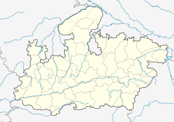
 Teonthar Location in Madhya Pradesh, India Show map of Madhya Pradesh  Teonthar Teonthar (India) Show map of India | |
| Coordinates: 24°59′N 81°39′E / 24.98°N 81.65°E / 24.98; 81.65Coordinates: 24°59′N 81°39′E / 24.98°N 81.65°E / 24.98; 81.65 | |
| Country | |
| State | Madhya Pradesh |
| District | Rewa |
| Tehsil | Teonthar |
| Government | |
| • Body | Nagar panchayat |
| Elevation | 151 m (495 ft) |
| Population (2001) | |
| • Total | 15,249 |
| Languages | |
| • Official | Hindi, Bagheli language |
| Time zone | UTC+5:30 (IST) |
| PIN | 486220 |
| ISO 3166 code | IN-MP |
| Vehicle registration | MP 17 |
| Lok Sabha Constituency | Rewa (Lok Sabha constituency) |
| Vidhan Sabha constituency | Teonthar |
Teonthar is a town and a nagar panchayat in Rewa district in the Indian state of Madhya Pradesh.
Contents
1 History
2 Geography
3 Location and Transportation
4 Demographics
5 References
History
Teonthar was once ruled by the Kol kings. Teonthar lies on one of the oldest routes between north India and south India. Teonthar is also known for its Deor kothar (Devanāgarī: देउर कोठार, also Deur Kothar) stupas. These Buddhists stupas are credited to the Mauryan emperor, Ashoka.
Geography
Teonthar is located at 24°59′N 81°39′E / 24.98°N 81.65°E / 24.98; 81.65.[1] It has an average elevation of 151 metres (495 feet). The town is situated on the banks of Tamsa River (also known as the Tons River) which is a tributary of the Ganges . Geographically, a large part of Teonthar is an alluvial plain.The alluvial plains of Teonthar are 100 metres (330 ft) in elevation. Due to its location and elevation, the area around Teonthar is flood prone.
Location and Transportation
Teonthar is located near the state borders of Madhya Pradesh and Uttar Pradesh. It is situated at a distance of about 77 kilometers from Rewa and about 60 kilometers from the city of Allahabad.The town is well connected to both Rewa and Allahabad via National Highway 30 (NH30). Nearest railway stations are Shankargarh, Allahabad and Rewa. Allahabad Airport (Bamrauli) is nearest airport.
Demographics
The town is divided into 15 wards and has a population of 17,039 (8,812 males and 8,227 females) according to 2011 census. 14.65% of total population of Teonthar is below 6 years of age. Sex ratio is 934 and average Literacy rate is 71.99% which is higher than state average of 69.32%. Hindus form 92.82% of the population whereas Muslims constitute 6.88%.
References
^ Falling Rain Genomics, Inc - Teonthar
This article related to a location in Madhya Pradesh is a stub. You can help Wikipedia by expanding it. |